Finding the Map
By Jacob Cytryn, Director
This past summer, we welcomed Nivonim 2000 to camp for their thirteenth-year reunion. As usual, it was a wonderful weekend for the alumni, their spouses and children, and it was great fun for me to reconnect with an eidah for which I hold a special affinity: my sister is in that eidah, as are many of the counselors I worked with as a Rosh Eidah. As we were reconnecting on Friday afternoon, however, little did I expect that treat that one alumna, Shira Goldstein, who now works at the National Museum of American Jewish History in Philadelphia, would offer: an aerial map of Camp Ramah in Wisconsin, drawn by camper Bill Agress in 1963.
The map itself is a bit like visiting an old house or neighborhood that we lived in many years ago. There are familiar landmarks but much is different. I am sure many alumni can shed some light on some of my questions: Why are cabins 3 and 6 connected, while halfway across camp sit 4 and 5? Did campers play in the swamps? Other answers, like why the artist/author chose to describe the “waterfront” may be lost to time and memory.
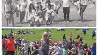
What is amazing, especially when we compare the 1963 map to recent aerial photographs, is how much of the camp is still where it once was, from the “main house” (now our business office) to beito (the “director’s cabin”), the merkaz (then “arts and crafts’), and the bet am (“social hall”), as well as many of the cabins. We now call the “guest house” OGH – the “original” (or, as some prefer, “old” guest house), having been supplanted by a newer version sometime in the intervening 50 years.


We know, however, from testimonials of grandparents who were themselves campers as well as many alumni who return to visit, that the physical changes in the camp, so noticeable upon one’s first arrival after years or decades away, are quickly overwhelmed and made irrelevant by that Ramah feeling which permeates the place. It still feels like the same place it once did; and many of the conversations, activities, and experiences that we see campers and staff having around the campus bring back sometimes visceral, often vivid memories of our own experiences years ago.
This past summer, my first as director, I remember clearly watching our youngest male campers schlep their bags across the basketball courts, down between the Beit Am and Beito, and then up what we once called “Chalutzim Hill” to the boys cabins (in 1992 when I arrived, as in 1963, #1-2). Every once in a while I’d catch a smell – French toast wafting through the Moadon during Shacharit or the indescribable fragrance of the trees along the garbage trail – that hauls me back to some moment in my Ramah past.
In the office, we love those moments when we hear from alumni of all ages about their Ramah memories, which confirms for us what we know: the place slowly changes and evolves, with hairstyles and how the kids wear their shorts and jeans and Shabbat outfits; but the experience, our mission and the core experience we provide to campers and staff, remains constant from generation to generation.
The Story Behind the Map
By Bill Agress
The question you may ask is, “How does a teenager from New Jersey go to Ramah in Wisconsin and how does a map he drew in 1963 wind up in Philadelphia 50 years later?”
My parents had heard about the Ramah camps from friends in New York. Now no child from Congregation Brothers of Israel in Trenton, New Jersey, had ever gone to Camp Ramah. By the time we inquired the only camps with room for me were Wisconsin and California. Since Wisconsin is closer to New Jersey, that’s where I went.
In the summer of 1963 I was in the Machon, and my cabin was Yud Alef, one of four very rustic log cabins on a hill side. My head madrich was Dave Benson and junior counselor was Ira Shoulson. Also living in our bunk was waterfront director Mike Menitoff. At night bats flew around just under the peaked roof of our cabin.
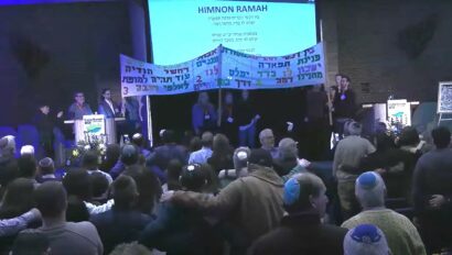
I remember one special morning we rowed out to an island in the lake where we davened, built a fire and made Rocky Mountain eggs. The musical performed that summer by Machon was My Fair Lady. I still remember the words in Hebrew to “Get me to the Bet Knesset on time.”
By the summer of 1964, there was room for me in the Poconos, so I never went back to Wisconsin. I also spent a summer at what was called the American Seminar at Ramah in Nyack, New York. Of the three Ramah experiences, my fondest memories are of Wisconsin.
So why did I draw the map? I found the size of the camp in Wisconsin a bit intimidating, and drew the map to help me navigate. I understand the swamp has been drained but back in 1963 it was cattails and marshland.
In 2010 I heard about the opening of the National Museum of American Jewish History in Philadelphia. I called one of the curators explaining that I still had all of my “stuff” from Ramah and USY in the 1960’s. They museum was very interested in my papers, play scripts, USY hat, Ramah t-shirt and sweatshirt, song books and even my map.
Camp Ramah undoubtedly changed my entire life. I am “multi-synagogal” – active at Adath Israel in Lawrenceville, New Jersey and the Perrineville New Jersey Jewish Center. I teach in the religious school of Brothers of Israel, now located in Newton, Pennsylvania. My son Andrew spent five summers at Ramah Poconos, was very active in USY and now attends Brandeis University.
I hope some day soon to get back to revisit my favorite memories at Camp Ramah in Wisconsin.
Correspondence Regarding the Map
By Jared Bryan
I’m not sure to whom to send this, but I have a small bit of input on Jacob Cytryn’s questions regarding the hand-drawn map in the cover story, and a possible reason for cabin 3/6 being together in 1963.
In 1963 I was in Cabin 9 overlooking Cabin 4/5. In 1962 that 4/5 location on the map was Cabin 5/6, and cabin 3/4 was where 3/6 was on the 1963 map. In 1962 I was in cabin 6, and it was my first year at Ramah. Unfortunately, in 1962 our cabin 5/6 burned to the ground shortly after visitors day. So, in 1963 cabin 4/5 would have been a brand new building. I really don’t know why the change was made to have cabins 4/5 in the new building and to move 6 to the other side of camp, but perhaps there was a 1963 cabin 6 camper or two who witnessed the fire in 1962, and it was decided to move their cabin to another location for 1963 while the traumatic memories of the fire were still so fresh in a young child’s mind.
For me, over 50 years later, I still vividly remember returning from softball practice with only the clothes on my back and my prized ball glove in hand to see my JC tossing a bucket of water on a fire in our utility closet area. What followed cemented my love for Ramah. The entire camp quickly formed two “bucket brigade” lines. Some of the adults were attempting (in vain) to douse the fire, but most of the camp was frantically emptying the library of all its books in a line of campers and staff stretching all the way to the Bet Am. By the time the volunteer fire department arrived and got their pumper truck pouring large quantities of lake water on the fire, there was really nothing left of cabin 5/6 except the twisted, melted metal of the bunk bed frames, but the library was saved from any significant collateral damage. The next day a school bus took all the Cabin 5/6 campers and staff to a general store (I think it was in Iron Mountain, MI) where we were bought a pair or two of blue jeans, some underwear, socks, a pair of shoes, toiletries and maybe a few other items that I no longer recall. We spent the rest of camp sleeping in borrowed sleeping bags on the porch floors of other cabins. For me, the bad experiences didn’t end with the fire or “porch bunking” because I developed pneumonia and had to be sent home (flying for my first time, on a DC3 out of an area airport). And yet, despite losing almost everything I treasured as a 13 year old, and getting sent home early with a debilitating illness, I still couldn’t wait to return the next year (and the next and next).
Both my children also attended Ramah Wisconsin, so I was blessed to come back several times as an adult too. Even 40+ years later, I could not walk by that (mapped cabin 4/5) location without thinking of that fateful fire day back in 1962.
Oh…and as campers we were absolutely forbidden to go to the “swamp” area (which was pretty much where the new ball field is now). I thought it was great that during one of my visits to see my kids that we actually got a tour of the current “swamp” area with an educational explanation of the flora and fauna inhabiting it.